
© Jeffrey Paduan 2024
Hiking, Biking, Swimming
Tahoe Donner HOA: has extensive and free hiking, biking, and equestrian trails, with access from the trailhead next door! Walk or ski up to Donner Ridge (admittedly it is an easier hike from the Glacier Way parking lot than from our house), down into the Euer Valley (the more direct access is from the end of Alder Creek Rd), or around the development’s perimeter. They’ve been expanding the single-track biking network. See the map of the Tahoe Donner trail system at the TD website (also on bookshelf in the living room).
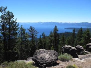
Tahoe Rim Trail - Picnic Rocks: A moderate ~3-mile hike with spectacular views awaits from a trailhead just after (S of) Brockway Summit on Hwy 267. Start up from the road and take a sharp left at the kiosk. After several switchbacks, look for the spur up to the viewpoint (photo at right).
Donner Memorial State Park: has a beautiful shoreline, great swimmng, and pretty trails. A vendor part way along the shore has SUP, kayak, and motor boat rentals. “Dog Beach” is on Donner Lake, accessed through the park, next to the Tahoe Donner Beach Marina (note that no dogs are allowed in the TD marina), on Donner Pass Road. A day-use fee is required. The Museum there is a must if you have time.
Truckee River Legacy Trail: is a bike trail along the Truckee River found from the very end of East River Street (cross the pedestrian bridge), or from the Truckee Regional Park on Brockway (at the E end of town, turn right on Bridge Street, cross the river where it becomes Brockway, and the park is on the left; work your way down to the lowest elevation parking lot). The paved bike trail goes along the river east to the Glenshire neighborhood. A footpath drops down along the river for much of the way, and is a safe trail for dogs, far from bikes and cars, and the river moves relatively gently (in the late summer at least). The Legacy Trail eventually goes all the way to Pyramid Lake past Reno, NV. See: Truckee River Legacy Trail website
Martis Creek Wildlife Area: is a large tract around Martis Creek is great for dogs, hiking, and biking. Take I-80 east past downtown Truckee, take the exit for SR 267, turn right (S) toward Northstar. After the airport, watch for "Wildlife viewing area” sign and turn right into the parking area.
Pacific Crest Trail: a wonderful scenic and dog-friendly trail goes south along the Pacific Crest Trail from old Donner Summit (trailhead off the entrance to SugarBowl; after the PCT crosses a couple ski runs, turn left to make a loop up and back along the ridge-line of Mt. Judah. The “5 Lakes” trail goes up from Alpine Meadows Road to the Pacific Crest Trail, past several small lakes between Alpine Meadows and Olympic Valley ski areas, one of which is swimmable.
Truckee Donner Land Trust trails - Donner Summit Canyon and more.
Shirley Canyon Trail: along the S side of the Squaw Creek up past Shirley Lake (swimmable) to the tram, which you (and your dogs!) can ride down for free if you hike up. Hike along the N side of the creek to get to the Pacific Crest Trail. Both ways are accessed from the farthest NW end of Palisades Tahoe's Olympic Valley parking lot.
Commemorative Emigrant Trail: runs along Alder Creek (accessed from Schussing Way and Alder Creek Road, just north of Tahoe Donner). Cross Alder Creek Road and follow the trail toward the Donner Picnic Area and Prosser Reservoir east of Hwy 89. Part way along, turn left and go up some banked S-turns built for mountain biking for nice views to the NE.
Rafting: Floating on the Truckee River from Lake Tahoe to Alpine Meadows Rd is very popular.
Lakes Basin: A good hour drive north of Truckee is a series of lovely lakes set in gorgeous high alpine country. Take 89N from Truckee, turn L to stay on 89N in Sierraville and (an easy to miss) R to stay on 89N toward Calpine/Clio north of that. As you reach Graeagle, turn left on Gold Lake Highway. Take that for several miles and turn right at a road marked for Lakes Basin Campground and Elwell Lakes Lodge. Pass those driveways and park at the dual-trailhead. You can make a relatively easy 5 mi loop of it, the dogs can get wet about every half mile so it’s safe even on a hot day, and take less-trodden spurs to find beautiful, deep swimming spots on several of the lakes. Dinner at Gold Lake Lodge (next side-road beyond, 2 seatings per evening) is a great way to finish a marvelous day.
Regional hiking and biking guide books and maps are on the bookshelf in the living room.
Truckee Trails Foundation: http://www.truckeetrais.org/trails has maps and trail descriptions.
AllTrails.com: https://www.alltrails.com/us/california/truckee for Truckee, and beyond.
Bike Tahoe trail guide: https://biketahoe.org