© Jeffrey Paduan 2024
Maps & Directions
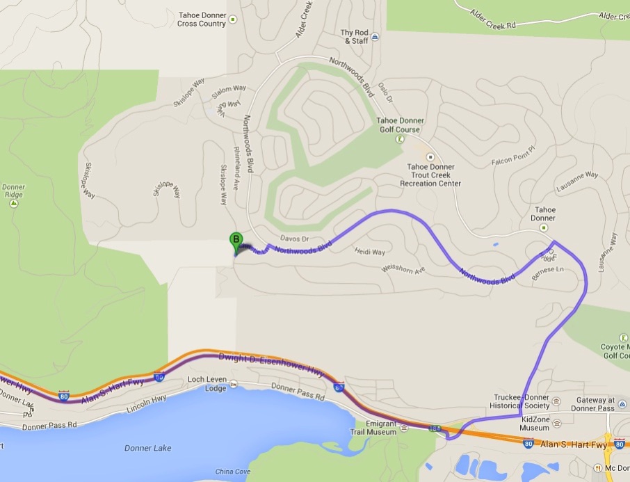
>> See the above as an interactive map in Google Maps
* The house is in the Tahoe Donner neighborhood of the Town of Truckee, north of Lake Tahoe.
* From Sacramento, take I-80 E toward Reno; from Reno, Take I-80 W toward Sacramento.
* Take the Donner Pass Road exit (westernmost of the 4 Truckee exits). From eastbound I-80, follow the roundabout to the left onto Donner Pass Road and cross over the highway bridge. From westboand, turn right onto Donner Pass Road.
* Turn left at the first light for Northwoods Blvd and climb the steep hill.
* At the first stop sign, at the intersection of Northwoods and Northwoods loop, turn left (i.e., take the south side of Northwoods loop...if you go straight and take the north side of the loop, you'll see signs for the Lodge and recreation centers; watch for Christie to eventually show up on your right in that case.)
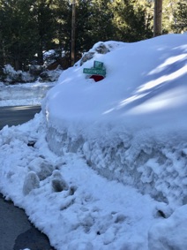
* In about 2.5 miles, turn left onto Christie (the sign might be buried as in the pic at right---LOL), then turn left onto Skislope. Ours is the fourth and final driveway on the right, #12678. If you come to Copenhagen or Teton Way, you've gone too far.
For your GPS: 12678 Skislope Way, Truckee CA 96161. If it does not find it, try "Ski Slope" as two words.
Online map of Tahoe Donner TahoeDonnerMap.pdf (also shows TD amenity locations)
Weather and Road Conditions
* CalTrans highway conditions; or call 1-800-427-ROAD and say or enter highway number. CalTrans District 3 Twitter feed has immediate information. The CalTrans QuickMap app and website have camera feeds and roadside notifications.
* Truckee Police and Fire Depts now use CodeRED to communicate with cell phones in the area (see Emergency page).
* Tire chains are required to be carried by all vehicles from 1 November to 1 May. If the weather is bad, CalTrans may require chains be installed, but usually only on 2-wheel drive vehicles (level R-2). The highways have wide, dedicated shoulder "chain up areas" for that purpose; there may be long back-ups approaching those sites.
* We have found that if conditions are so bad that chains would be required on 4-wheel drive vehicles (level R-3), CalTrans will err on the side of safety and close the highway. Be prepared for long delays and the possibility of being turned back to spend the night in Auburn or Sacramento.
* Be sure to have winter clothing, food, and water in your vehicle. Fuel up before heading beyond Auburn. Windshield wiper fluid containing antifreeze can be purchased in Auburn (it is illegal to be sold at lower elevations in California for air pollution avoidance).
* Read: CalTrans Winter Driving Tips
* NOAA weather, NOAA forecast discussion, SpotWx.com, Open Snow, Wunderground, and Windy.com are good sources for forecasts and current conditions.
Transportation options
For scheduled flights, check Reno-Tahoe Airport (RNO; 45 minutes away) and Sacremento (SAC; just under 2 hours away). We recommend renting an AWD vehicle in the winter months. (You can also purchase tire chains at Les Schwab and return them to the shop for a refund if unused.)
Other transportation resources:
Truckee Chamber of Commerce and their Transportation page
Tahoe Area Rapid Transit buses (TART)
ATGRIDE.com (All Star Transportation 530-448-2442; Eric Heydorff 530-807-7201)
UBER and Lyft operate in Truckee